
Before you head out on the trails, there is one thing that will make your entire day go smoother.
Knowing the rules.
Sedona’s backcountry is extraordinary. It is also carefully managed. The Red Rock Ranger District oversees a trail network that balances public access with land protection, and understanding how that system works before you rent a UTV is the difference between a great day and a frustrating one.
The good news is that the rules are not complicated once you understand the framework. This guide walks you through exactly where you can legally drive, how to read the maps and signs you will encounter on the trail, and how to ride in a way that keeps Sedona’s backcountry open and intact for everyone who comes after you.
Quick Answer: Sedona UTV rentals are restricted to designated OHV routes managed by the Red Rock Ranger District. Staying on marked motorized trails, respecting closures, and following posted signs keeps your ride legal and the land protected.
Key Takeaways
- UTV and OHV use in Sedona is restricted to designated motorized routes only
- Public roads in Sedona are not legal for UTV operation
- Trail maps from the Red Rock Ranger District identify legal OHV routes clearly
- Trail closures and signs must be observed and carry real consequences if ignored
- Sedona Off Road Center briefs every renter on approved routes before departure
Where Can You Legally Drive a UTV in Sedona?
This is the most important question to answer before you ever leave the rental lot.
Not all land in Sedona is open to motorized vehicles. The area is managed by several overlapping jurisdictions including the Coconino National Forest, the Red Rock Ranger District, Arizona State Land Department parcels, and private property. Each jurisdiction has its own rules, and the lines between them are not always obvious from the trail.
The short answer is this: you can legally drive a UTV only on routes that are specifically designated for motorized OHV use.
That designation comes from the Red Rock Ranger District’s motor vehicle use map, which identifies every route where OHV access is permitted. Routes not appearing on that map as motorized routes are off limits, regardless of how passable the terrain looks or how natural it feels to keep driving.
Public roads in and around Sedona are not legal for UTV operation. UTVs rented from Sedona Off Road Center are off-road vehicles and are not street legal. You cannot drive them on Highway 179, Schnebly Hill Road from the pavement, or any other public street.
All riding begins and ends at the Sedona Off Road Center facility, where the team walks you through the approved trail network and access points before you head out.
Key designated OHV trails in Sedona’s approved network:
- Schnebly Hill Trail
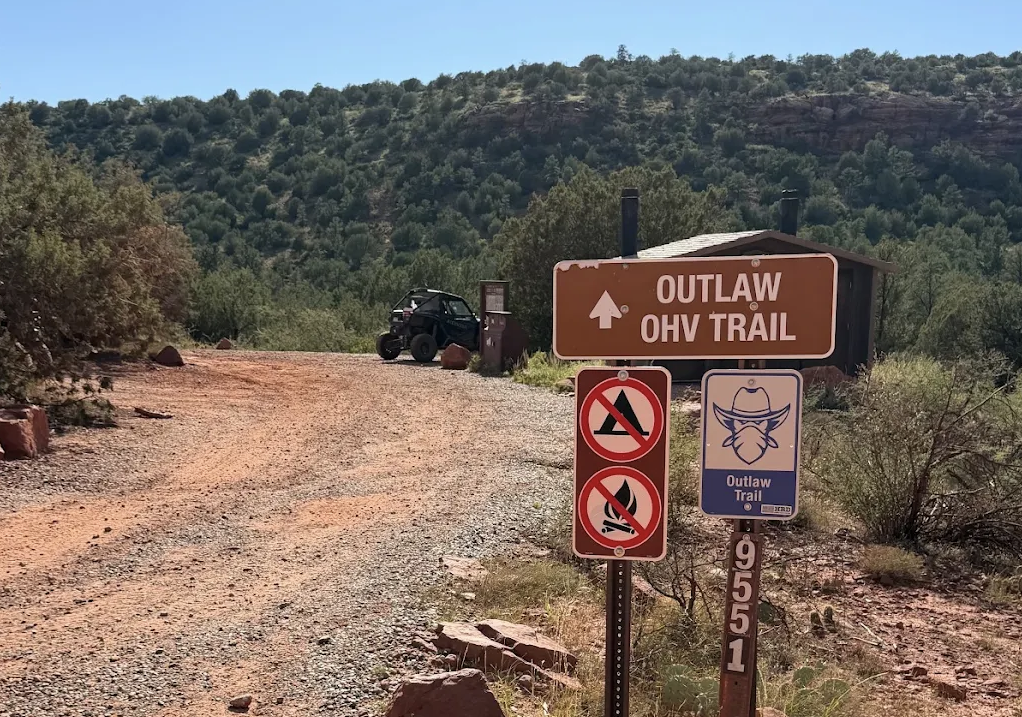
- Outlaw Trail
- Diamondback Gulch
- Vultee Arch Road
- Ranch Loop
- Powerline Trail
These are the routes where your Honda Talon belongs. Everything else is out of bounds.
Understanding the Land Around You
Sedona’s landscape looks continuous from the trail, but the land management beneath it is a patchwork.
Coconino National Forest land makes up a large portion of the trail network and is managed by the U.S. Forest Service under the Red Rock Ranger District. OHV use on National Forest land in Sedona requires staying on designated routes only. Cross country travel, which means driving off a marked route onto unmarked terrain, is not permitted and carries federal consequences.
State Trust Land parcels appear throughout the Sedona area as well. Access rules on these parcels vary, and some require a State Trust Land recreation permit for non-motorized use. For OHV riders, the same principle applies: stay on designated routes and verify access before venturing onto parcels not clearly part of the approved trail network.
Private land borders many trail sections. Riding onto private land is trespassing, regardless of whether a fence or gate is visible.
The simplest rule is also the most effective one. Stay on the route. If you are unsure whether a branch, spur, or fork is an approved motorized route, the answer is to not take it until you can confirm.
How to Read Sedona’s Off-Road Trail Maps
The Red Rock Ranger District’s Motor Vehicle Use Map is the authoritative document for OHV riders in Sedona.
The map distinguishes between different types of routes using a clear coding system:
Roads open to all motor vehicles are open to street legal vehicles and may overlap with OHV routes in some sections.
Trails open to highway legal vehicles are paved or improved surfaces open to licensed, street legal vehicles only. These are not OHV routes.
Trails open to all motor vehicles including OHV are your designated riding routes. This is where your UTV belongs.
Routes that are not coded for motorized use do not appear as legal options, even if they appear as physical trails on a topographic or hiking map.
When planning your ride, always cross reference the motor vehicle use map rather than relying on a general hiking or scenic map. Hiking trails, non-motorized paths, and OHV routes often run through the same general corridor but are distinct designations with different rules.
Sedona Off Road Center provides renters with trail maps and route guidance before departure. Use those resources. They are specific to the current approved network and reflect any active closures or route changes.
Off-Road Route Classification at a Glance
| Route Type | Who Can Use It | UTV Access | Notes |
| Designated OHV motorized route | All motor vehicles including off-road | Yes | Stay on marked route at all times |
| Highway legal vehicle route | Street legal vehicles only | No | Not open to rental UTVs |
| Non-motorized trail | Hikers, bikers, equestrian users | No | Never cross onto these routes |
| Cross country terrain | No one | No | Prohibited throughout Coconino NF |
| Private land | Owner permission required | No | Trespassing laws apply |
| State Trust Land parcel | Permit may be required | Verify before accessing | Check designation before entry |
What Trail Signs and Closures Mean for UTV Drivers
Sedona’s trail network uses a consistent system of signs to communicate access rules, route boundaries, and closures. Knowing what these signs mean before you encounter them makes your ride smoother and keeps you on the right side of the regulations.
Route marker posts appear at trail heads and key intersections to identify the official route number or name. These are your confirmation that you are on a designated motorized route.
No motor vehicle signs appear where motorized access ends or where a spur route transitions from OHV to non-motorized use. These signs mean stop and turn around, regardless of how open the terrain looks beyond the marker.
Trail closed signs indicate a temporary or permanent closure of a specific route. Closures occur for a range of reasons including erosion repair, habitat protection, fire recovery, and seasonal conditions. Entering a closed route is a federal violation and contributes to the conditions that lead to longer closures.
Boundary and private property markers define the edge of National Forest land or the beginning of private parcels. These require an immediate change of direction.
Restoration area signs mark land that has been damaged by previous off-trail use and is actively recovering. These areas have no motorized access of any kind and are among the most important signs to honor.
Active Closures and How to Check Before You Ride
Trail conditions and closures in Sedona change based on weather events, land management decisions, and seasonal factors.
A route that was open on your last visit may be temporarily closed when you arrive. Checking current conditions before heading out is part of responsible riding.
Where to check:
- The Red Rock Ranger District website and visitor center in Sedona
- The Coconino National Forest recreation page
- Sedona Off Road Center staff, who monitor trail conditions and closures regularly and will advise you on current route availability before you depart
Do not rely on trail review apps, social posts, or word of mouth for closure information. Official sources reflect current conditions. Everything else may be outdated.
Trail Sign Reference for UTV Riders
| Sign Type | What It Looks Like | What It Means for You | Required Action |
| Route marker post | Numbered post at trailhead or fork | You are on a designated route | Continue on route, note the number |
| No motor vehicles | Symbol with vehicle and slash | Motorized access ends here | Stop and turn around |
| Trail closed | Posted barrier or closure sign | Route is temporarily or permanently closed | Do not enter under any circumstances |
| Restoration area | Posted boundary markers | Land is actively recovering from damage | No access, any motorized use prohibited |
| Private property boundary | Fence, post, or posted sign | National Forest land ends | Turn around, do not cross boundary |
| Wilderness area boundary | Posted sign at entry point | Motorized vehicles completely prohibited | Turn around immediately |
How to Respect Red Rock Country While Riding
Following the rules is the baseline. Riding responsibly goes a step further.
Sedona’s backcountry is not just a trail network. It is a living landscape that supports diverse ecosystems, prehistoric cultural sites, and a geology that took millions of years to produce. Every rider who treats that landscape with care helps keep it intact for the next person who wants the same experience.
Stay on the designated route at all times. This is the most important practice in off-road riding. A single shortcut across unmarked terrain can compact soil, damage plant root systems, and create erosion patterns that take years to repair. The trail is the trail. There is no good reason to leave it.
Do not approach or enter cultural or archaeological sites. Sedona’s backcountry contains prehistoric ruins, rock art, and other cultural features that are protected under federal law. If you spot what appears to be a ruin or petroglyph panel from the trail, observe it from a respectful distance and do not disturb the surrounding area.
Pack out what you bring in. Nothing leaves the trail except tire tracks. No trash, no food waste, no gear, no materials of any kind should be left on the trail or at viewpoints.
Yield to non-motorized users. Hikers and equestrian users have the right of way on shared trail corridors. Slow to a stop when approaching them, allow ample space, and be aware that horses in particular may react to the sound of a vehicle.
Avoid riding on wet or muddy trails. Wet conditions dramatically increase the impact of motorized use on trail surfaces. Riding through wet terrain creates ruts, compacts soil, and causes erosion that widens trail damage far beyond the original route. If conditions are wet, check with Sedona Off Road Center before heading out.
Keep noise to a reasonable level. Sedona’s backcountry is shared with hikers and other visitors who come specifically for the quiet. Excessive engine noise disrupts that experience and reflects poorly on the off-road community as a whole.
Responsible Riding Practices at a Glance
| Practice | Why It Matters | How to Apply It |
| Stay on designated routes | Prevents erosion and soil compaction | Never leave the marked trail |
| Observe all closures | Protects recovering land and avoids violations | Check current closures before departure |
| Yield to other trail users | Required by trail etiquette and courtesy | Slow and stop for hikers and horses |
| Pack out all waste | Maintains trail quality for future riders | Carry a bag and leave nothing behind |
| Avoid wet terrain | Reduces trail damage from motorized use | Check conditions, skip wet routes |
| Respect cultural sites | Required by federal law and basic ethics | Observe from a distance, never touch |
| Keep noise reasonable | Protects the experience for everyone | Avoid revving unnecessarily near other users |
What Sedona Off Road Center Does to Keep Riders Informed
Before any renter leaves the lot, Sedona Off Road Center walks them through the approved trail network, current conditions, and what to watch for on the route.
This is not just paperwork. It is a genuine orientation designed to set riders up for a great day. The team knows the current closure status, the trail conditions, and the route details that make each ride more rewarding.
If you have questions before you book or on the day of your rental, ask them. The team is there to help you make the most of your time on the trail without running into avoidable complications.
Know Before You Go
Sedona’s off-road rules exist for good reason. The landscape is extraordinary because it has been protected, managed, and respected by the people who ride through it.
Understanding where you can legally drive, how to read the signs and maps, and how to ride with care does not diminish the adventure. It grounds it in something real. You are riding through one of the most remarkable landscapes in North America. The rules help keep it that way.
Book your Honda Talon with Sedona Off Road Center, get your route briefing from the team, and head out knowing exactly where you stand.
Call (928) 284-4735 or book your rental online today.
Frequently Asked Questions
Q: Can you drive a UTV on public roads in Sedona?
A: No. Rental UTVs from Sedona Off Road Center are off-road vehicles and are not street legal. They are not permitted on public roads in or around Sedona.
Q: What trails can you legally drive a UTV on in Sedona?
A: Legal OHV trails in Sedona include Schnebly Hill Trail, Outlaw Trail, Diamondback Gulch, Vultee Arch Road, Ranch Loop, and Powerline Trail, among others on the Red Rock Ranger District’s designated motorized route network.
Q: What happens if you ride on a closed trail in Sedona?
A: Entering a closed trail on Coconino National Forest land is a federal violation. Consequences can include fines and citation. Sedona Off Road Center briefs renters on current closures before departure.
Q: How do you know if a trail is open or closed in Sedona?
A: Check the Red Rock Ranger District website or ask the team at Sedona Off Road Center before heading out. They monitor current trail conditions and closures and will advise you accordingly.
Q: Can you go off trail in Sedona with a UTV?
A: No. Cross country travel, meaning driving off a designated motorized route onto unmarked terrain, is prohibited throughout the Coconino National Forest. Stay on the marked route at all times.
https://maps.app.goo.gl/DhuPzXtzPu3jRvS5A
Created on 11-02-26